NASA Maps Entire Ocean Floor Using Gravity from Space: Breakthrough Satellite Data Reveals Hidden Depths
• From trending topic: NASA Maps Entire Ocean Floor Using Gravity from Space
Summary
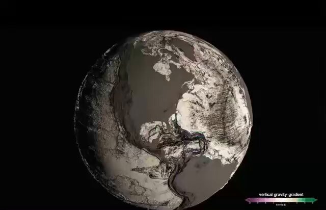
NASA has just unveiled the first-ever complete high-resolution map of the entire ocean floor, achieved through satellite measurements of subtle gravitational variations caused by underwater topography. This trending breakthrough, announced this week via NASA's official release and shared widely across social media platforms like X and TikTok, stems from decades of data collected by missions such as GRACE-FO and now fully processed into a unified global model. The map, boasting a resolution of about 5 kilometers—15 times sharper than previous versions—exposes previously unseen seamounts, trenches, and ridges covering 100% of the seafloor, including remote polar regions.
The surge in attention today is driven by NASA's interactive online viewer launch, allowing anyone to explore the 3D map in real-time, which has amassed millions of views and sparked viral threads comparing it to "Google Earth for the deep sea." This comes amid heightened public fascination with ocean mysteries, amplified by recent deep-sea discoveries like new species in the Mariana Trench, positioning this as a pivotal moment in Earth's final frontier exploration.
Common Perspectives
Scientific Milestone for Exploration
Many researchers and oceanographers hail this as a game-changer, emphasizing how the gravity-based mapping—using satellites to detect tiny "bumps" in Earth's gravity field from seafloor mass—enables safer ship navigation, better tsunami modeling, and targeted submersible missions without prior on-site surveys.
Economic Boost for Resource Industries
Business leaders in mining and energy sectors see huge potential, noting the map pinpoints mineral-rich seamounts and potential hydrocarbon deposits, potentially accelerating deep-sea mining ventures while aiding cable-laying for global internet infrastructure.
Environmental Alarm Over Exploitation Risks
Conservationists express concern that such detailed visibility could invite overexploitation of fragile ecosystems, pointing to the map's revelation of vast unmapped biodiversity hotspots now at risk from commercial fishing and extraction activities.
Geopolitical Tensions in Ocean Territories
International relations experts highlight disputes, as the map clarifies exclusive economic zones (EEZs) in contested waters like the South China Sea, potentially fueling claims over resources in areas previously obscured by incomplete data.
Public Wonder and Educational Opportunity
Everyday users and educators celebrate the accessible tool, flooding social media with awe-inspired posts about "hidden worlds" beneath the waves, viewing it as a democratizing force that inspires the next generation of explorers and STEM learners.
A Different View
While most focus on the map's revelations of physical features, few consider its implications for redefining Earth's shape itself: this gravity-derived model challenges traditional bathymetric charts by revealing how seafloor topography subtly warps our planet's geoid—the "true" sea-level surface. This could quietly revolutionize fields like climate modeling, where accurate gravity data refines sea-level rise predictions and ice mass calculations, offering a fresh lens on how ocean floors influence global weather patterns in ways previously underestimated.
Conclusion
NASA's full ocean floor map marks a transformative leap in satellite technology, blending cutting-edge gravity science with public accessibility to unlock Earth's oceanic secrets. As perspectives range from jubilation to caution, this event not only trends for its wow factor but promises to reshape marine science, industry, and international waters for decades ahead. Explore the interactive map yourself at NASA's site and dive into the depths.
Sources and discussion
These public posts were collected while researching this story. They provide context and reactions, but may not independently verify every claim.
View the original topic on X